Why Site Selection Makes or Breaks Multi-Residential Projects
For property developers in Melbourne, the difference between a profitable multi-residential project and a costly mistake often comes down to site selection. With planning permit approval rates varying significantly between councils—and between sites within the same council—understanding what makes a site viable before you commit capital is critical.
This guide outlines the key selection criteria for multi-residential sites in Melbourne, drawing on SQM Architects’ experience with 210+ projects across Whitehorse, Boroondara, Manningham, Monash, Knox, and Maroondah councils. We’ll cover zoning fundamentals, physical site constraints, planning scheme variations, and the practical site assessment process that can help you identify sites with strong approval potential before you make an offer.
The assessment framework presented here reflects current Victorian planning provisions, including recent amendments VC282 and VC267 that have introduced new design requirements and deemed-to-comply pathways for townhouse and low-rise developments. Understanding these criteria upfront may help you avoid sites that appear attractive on price but carry hidden planning risks.
Zoning and Planning Scheme Fundamentals
The first filter in any multi-residential site assessment is zoning. In Melbourne, the most common zones for multi-residential development are General Residential Zone (GRZ), Neighbourhood Residential Zone (NRZ), and Residential Growth Zone (RGZ). Each zone has different development potential, and understanding the nuances can significantly impact your project feasibility.
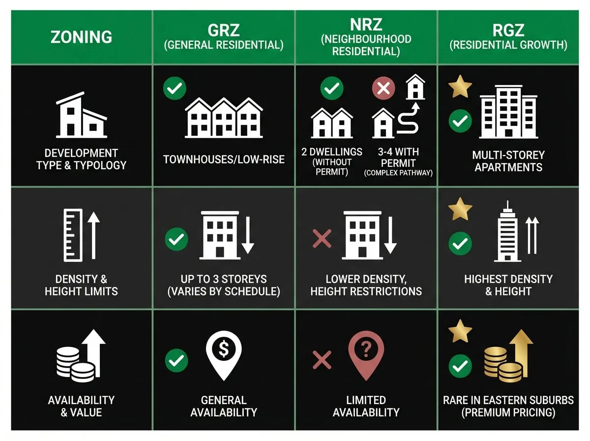
General Residential Zone sites typically allow for townhouses and low-rise apartments without a planning permit for buildings up to three storeys (depending on the schedule). However, GRZ schedules vary considerably between councils. City of Whitehorse applies GRZ1, which generally supports medium-density development, while City of Boroondara uses multiple GRZ schedules with varying height limits and setback requirements. A GRZ site in one council may support eight dwellings, while a similar-sized GRZ site in another council may be limited to four.
Neighbourhood Residential Zone sites are more restrictive, typically limiting development to two dwellings per lot without a planning permit. While NRZ sites can sometimes support townhouse developments of three to four dwellings, the planning pathway is more complex and approval rates tend to be lower. Projects we’ve worked on suggest NRZ sites require stronger design responses to neighbourhood character and often face more objections from neighbouring properties.
Residential Growth Zone sites offer the highest development potential, supporting multi-storey apartments and higher dwelling densities. However, RGZ is relatively rare in Melbourne, concentrated in activity centres and major transport corridors. These sites typically command premium prices that reflect their development potential, and competition from larger developers can be significant.
Beyond the base zone, you’ll need to review the planning scheme schedule for your specific site. Schedules set out mandatory height limits, setback requirements, and sometimes dwelling density controls. For example, some GRZ schedules in Manningham City Council include maximum dwelling density requirements that can limit development potential regardless of site size. These schedule provisions are mandatory—they cannot be varied through design excellence or planning arguments.
Physical Site Characteristics and Constraints
Once you’ve confirmed favourable zoning, the next assessment layer is physical site characteristics. Even well-zoned sites can be unsuitable for multi-residential development due to topography, access, or environmental constraints.
Site dimensions and orientation are fundamental. For townhouse developments, a minimum site width of 18-20 metres typically allows for efficient layouts with side-by-side dwellings and central driveway access. Narrower sites may require tandem layouts or single-loaded access, which can reduce development yield. Sites with north-facing rear boundaries generally perform better under ResCode solar access requirements, particularly the daylight to existing windows standards introduced under VC282.
Topography can significantly impact development costs and planning outcomes. Sites with cross-falls exceeding 1:10 often require split-level designs, retaining walls, and more complex drainage solutions. While sloping sites aren’t necessarily unviable, the additional construction costs need to be factored into feasibility. Steep sites (cross-falls exceeding 1:5) may also trigger additional planning requirements around visual bulk and neighbourhood character impact.
Access and frontage are critical. Most multi-residential developments require vehicle access from the street frontage, and sites on busy roads or within 100 metres of signalised intersections may face access restrictions. City of Whitehorse and City of Boroondara both have specific policies around vehicle crossovers on classified roads. Corner sites often offer better access options and can support higher densities, but they also face more stringent setback requirements on both street frontages.
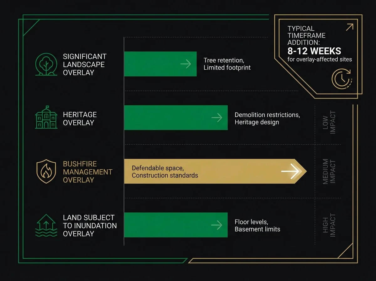
Environmental overlays can constrain or prohibit development. Common overlays in Melbourne include:
- Significant Landscape Overlay (SLO): Protects significant trees and vegetation, often requiring retention of canopy trees and limiting building footprints
- Heritage Overlay (HO): May restrict demolition and require heritage-sensitive design, significantly impacting development potential
- Bushfire Management Overlay (BMO): Requires defendable space and construction standards, more common in outer Melbourne
- Land Subject to Inundation Overlay (LSIO): Indicates flood risk, requiring floor level requirements and potentially limiting basement construction
Sites with multiple overlays or restrictive overlay schedules may require specialist consultants (arborists, heritage architects, bushfire planners) and face longer approval timeframes. Analysis of similar sites suggests overlay-affected sites in City of Boroondara can add 8-12 weeks to planning permit processing times.
Get the 7-point site check to run before committing to a permit application — zoning, overlays, setbacks and council red flags, in plain English. Free PDF, instant download.
- Zone, overlay & setback checks
- What council assesses first
- Permit-readiness red flags
Something went wrong. Please try again.
No spam. Unsubscribe anytime.
Check your inbox — your checklist is on its way.
ResCode Compliance and Design Standards
Understanding how a site will perform against ResCode standards is essential for predicting approval likelihood. The recent VC282 amendment updated Clause 54 with new design requirements that affect site selection criteria, particularly around setbacks, tree canopy coverage, and daylight to existing windows.
Street setback requirements vary by council and zone schedule, but most Melbourne councils require 6-9 metre front setbacks for multi-residential development. The VC282 amendment introduced more specific requirements around building height in relation to street setbacks, with taller buildings requiring greater setbacks to maintain streetscape character. Sites with shallow frontage depths (less than 30 metres) may struggle to achieve compliant setbacks while maintaining viable building depths.
Side and rear setbacks follow the ResCode formula: 1 metre plus 0.3 metres for every metre of building height above 3.6 metres. For a two-storey building (approximately 7 metres high), this typically requires 2-2.5 metre side setbacks. Sites with narrow widths (less than 15 metres) often cannot achieve compliant side setbacks for dual-occupancy or townhouse layouts without relying on design variations, which reduce approval certainty.
The daylight to existing windows standard introduced under VC282 is particularly relevant for infill sites. This standard requires that new development not reduce daylight to existing habitable room windows on neighbouring properties below specified levels. Sites surrounded by two-storey dwellings with windows facing the boundary may face significant constraints, particularly on the southern boundary where overshadowing is most pronounced. Common patterns show sites in established areas of Knox City Council and Maroondah City Council often face challenges meeting this standard.
Tree canopy coverage requirements under VC282 mandate minimum canopy coverage across the development site, typically 20-30% depending on the zone and council. Sites with limited deep soil area or constrained by existing buildings may struggle to achieve compliant canopy coverage. This is particularly relevant for sites under 600 square metres, where the combination of building footprint, car parking, and deep soil requirements can leave insufficient space for canopy trees.
Car parking requirements remain a significant site selection consideration. Most Melbourne councils require two spaces per dwelling for townhouses, plus visitor parking at a rate of one space per five dwellings. Sites need sufficient width and depth to accommodate parking layouts that meet Australian Standards for vehicle manoeuvring. Tandem parking (one space behind another) is generally acceptable for individual dwellings but not for visitor spaces.
Council-Specific Variations and Local Policies
While ResCode provides the state-wide framework, each council in Melbourne applies local policies and schedules that significantly affect site selection. Understanding these variations is critical for accurate feasibility assessment.
City of Whitehorse has relatively development-friendly policies for multi-residential projects, particularly in GRZ areas. The council’s planning scheme includes specific precinct policies that encourage medium-density development near activity centres and public transport. However, Whitehorse applies strict neighbourhood character policies in certain precincts, particularly in the Garden Suburb areas around Box Hill and Blackburn. Sites in these precincts may face additional design requirements around building materials, front fence heights, and garden area.
City of Boroondara is known for more conservative planning policies and stronger neighbourhood character protections. The council applies multiple GRZ schedules with varying height limits, and many areas have Significant Landscape Overlays that protect mature trees. Boroondara also has specific policies around front fence heights (typically limited to 1.2 metres) and requires higher-quality materials for multi-residential developments. Projects in Boroondara typically require more detailed design development at the planning permit stage and face higher rates of third-party objections.
Manningham City Council applies dwelling density controls in some GRZ schedules, limiting development to one dwelling per specified site area (e.g., one dwelling per 300 square metres). These density controls are mandatory and cannot be varied, making them a critical site selection filter. Manningham also has extensive Heritage Overlay areas, particularly in Bulleen and Templestowe, where demolition of existing dwellings may require separate heritage permits.
City of Monash generally supports medium-density development in GRZ areas, particularly near activity centres like Clayton and Glen Waverley. However, the council applies specific design guidelines for multi-residential development that emphasise building articulation, material quality, and landscaping. Monash sites near railway stations may benefit from reduced car parking requirements under the council’s sustainable transport policies.
Knox City Council and Maroondah City Council have similar planning frameworks, with GRZ areas concentrated near activity centres and most residential areas zoned NRZ. Both councils apply neighbourhood character policies that favour lower-density development, and sites in NRZ areas typically face more challenging approval pathways. Knox has specific policies around tree retention that can affect development yield on vegetated sites.
Practical Site Assessment Process
With the criteria established, here’s a practical framework for assessing multi-residential sites before making an offer. This process can often be completed within a few days for most sites, allowing you to move relatively quickly in competitive markets while managing risk.
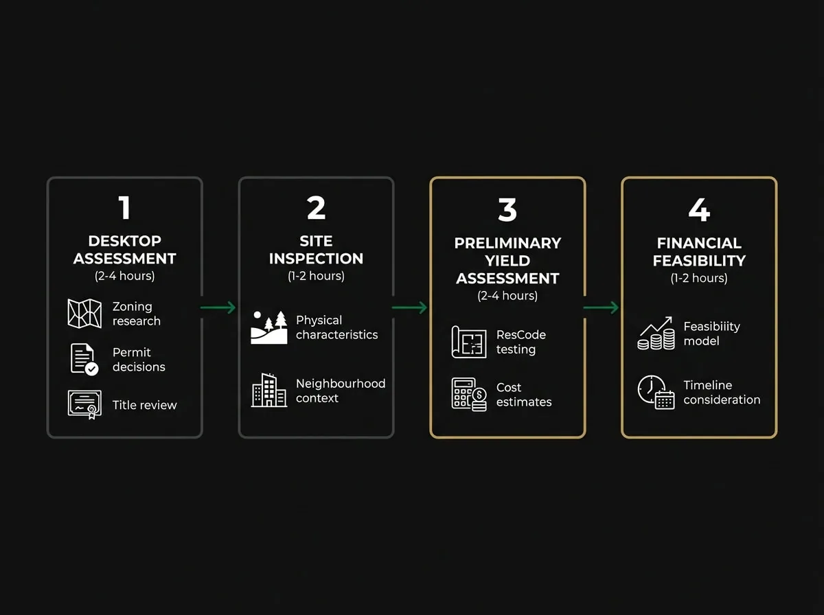
Stage 1: Desktop Assessment (2-4 hours)
Start with online planning scheme research using the relevant council’s planning maps and scheme documents. Confirm the zoning, identify any overlays, and review the zone schedule for mandatory height limits, setback requirements, and density controls. This initial filter can eliminate unsuitable sites before you invest in detailed analysis.
Review recent planning permit decisions for similar sites in the same area. Most councils publish planning permit decisions online, and reviewing 5-10 recent decisions can reveal local approval patterns, common objection themes, and design expectations. Pay particular attention to VCAT decisions if the site is in an area with high objection rates.
Obtain a copy of the title and planning certificate (Section 32 statement). The title will show easements, covenants, and encumbrances that may affect development. Common issues include drainage easements that limit building locations, restrictive covenants that limit dwelling numbers, and rights of way that affect access options.
Stage 2: Site Inspection (1-2 hours)
Visit the site and surrounding area to assess physical characteristics and neighbourhood context. Key observations include:
- Topography and drainage patterns
- Existing vegetation, particularly large canopy trees
- Neighbouring development patterns and building heights
- Street character and predominant architectural styles
- Access points and traffic conditions
- Proximity to amenities, public transport, and activity centres
Photograph the site from multiple angles, including views from neighbouring properties where visible from public areas. These photos will be valuable for preliminary design discussions and can help identify potential objection points from neighbours.
Stage 3: Preliminary Yield Assessment (2-4 hours)
Based on the desktop research and site inspection, prepare a preliminary yield assessment. This doesn’t require detailed architectural drawings—a simple bubble diagram showing potential dwelling locations, access, and parking can be sufficient for initial feasibility.
Test the site against key ResCode standards: setbacks, overshadowing, daylight to existing windows, and car parking. Sites that cannot achieve compliant outcomes for these standards may require design variations, which reduce approval certainty and can extend timeframes. Sites requiring multiple design variations may face reduced approval certainty and longer processing times.
Calculate indicative development costs based on the preliminary yield. Include allowances for site works (retaining walls, drainage, services), construction costs (which vary based on specification and site conditions), and professional fees. Sites with significant topography or overlay constraints may require additional consultant fees for arborists, heritage architects, or traffic engineers.
Stage 4: Financial Feasibility (1-2 hours)
Prepare a high-level feasibility model using the preliminary yield and cost estimates. Compare the total project cost (land, construction, fees, finance) against estimated end values based on recent sales of comparable new townhouses in the area. Developers typically account for market variations and holding costs in their feasibility modelling.
Consider the development timeline in your feasibility. Sites with straightforward planning pathways may achieve permits in 3-4 months, while sites requiring design variations, overlay permits, or likely VCAT appeals may take 9-12 months. The extended holding costs and market risk on longer-timeline sites need to be factored into your offer price.
Common Site Selection Mistakes to Avoid
Even experienced developers can overlook critical site selection factors. Here are common mistakes observed across numerous projects in Melbourne:
Overvaluing corner sites: While corner sites offer access advantages, they also face setback requirements on both street frontages, which can reduce developable area. Corner sites in Heritage Overlay areas or with Significant Landscape Overlays may face additional constraints that offset their access benefits.
Ignoring neighbourhood context: Sites that are significantly larger or smaller than surrounding lots often face neighbourhood character objections. A 1,200-square-metre site surrounded by 600-square-metre lots may support higher density on paper, but the planning assessment will consider whether the proposed development respects the established pattern. Developments that are substantially larger than the neighbourhood average typically face higher objection rates.
Underestimating overlay impacts: Heritage Overlays and Significant Landscape Overlays can add significant costs and timeframes to projects. A site with a Heritage Overlay may require heritage consultant reports, specialist design input, and potentially separate demolition permits. Sites with significant trees under SLO may require tree retention that limits building footprints and increases construction complexity.
Assuming zoning equals approval: A site zoned GRZ is not automatically suitable for multi-residential development. The zone schedule, overlays, and local policies all affect what can be achieved. Sites in GRZ with restrictive schedules may be less viable than well-located NRZ sites with supportive council policies.
Neglecting access and services: Sites with poor vehicle access, inadequate stormwater drainage, or limited service connections can face significant additional costs. Sites on narrow streets may require traffic management plans, and sites in areas with limited sewer capacity may require infrastructure contributions. These costs can materially affect project feasibility.
Due Diligence Checklist for Multi-Residential Sites
Before making an offer on a multi-residential site, complete this due diligence checklist:
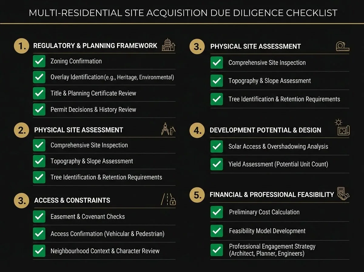
- Confirm zoning and review zone schedule for mandatory controls
- Identify all overlays and review overlay schedules
- Obtain title and planning certificate (Section 32)
- Review recent planning permit decisions in the area
- Inspect site and photograph from multiple angles
- Assess topography and identify any significant level changes
- Identify significant trees and vegetation
- Check for easements, covenants, and encumbrances on title
- Confirm vehicle access points and crossover locations
- Review neighbouring development patterns and building heights
- Assess solar access and overshadowing impacts
- Prepare preliminary yield assessment against ResCode standards
- Calculate indicative development costs including site works
- Prepare high-level feasibility model with realistic timeframes
- Consider engaging a town planner or architect for preliminary assessment
For sites with complex planning issues or significant constraints, engaging professional advice before making an offer can provide valuable risk mitigation. A preliminary planning assessment from an experienced architect or town planner can identify fatal flaws before you commit capital.
What’s the minimum site size for viable multi-residential development in Melbourne?
Minimum viable site size varies by council and zoning, but generally 600-700 square metres is the threshold for townhouse developments of 3-4 dwellings. Sites below 600 square metres may struggle to achieve compliant setbacks, car parking, and deep soil areas while maintaining viable dwelling sizes. In councils with dwelling density controls like Manningham, minimum site size may be higher (e.g., 900 square metres for three dwellings if the schedule requires 300 square metres per dwelling).
How do I know if a site will face neighbourhood objections?
Sites most likely to face objections are those that significantly exceed the prevailing development pattern, are located in established low-density areas with strong neighbourhood character, or involve demolition of heritage or character buildings. Reviewing recent planning permit decisions in the immediate area can reveal objection patterns. Sites in City of Boroondara and areas with Heritage Overlays typically face higher objection rates than sites in City of Whitehorse GRZ areas.
Can I rely on deemed-to-comply pathways under VC267?
The VC267 amendment introduced deemed-to-comply pathways for townhouse and low-rise developments that meet specific design standards. However, these pathways are only available for sites that fully comply with all relevant standards—any variation triggers the standard planning permit process. In practice, most sites in Melbourne require at least minor variations due to existing neighbourhood constraints, making deemed-to-comply pathways less common than initially anticipated. Learn more about ResCode compliance requirements.
What’s the typical timeframe from site purchase to planning permit approval?
For straightforward sites in supportive councils like City of Whitehorse, the timeline from purchase to permit approval may be 4-6 months (including 6-8 weeks for design development and 8-12 weeks for permit processing). Sites requiring design variations, overlay permits, or facing likely objections may take 9-12 months. Sites that proceed to VCAT can take 12-18 months from purchase to final approval. These timeframes should be factored into feasibility modelling and holding cost calculations.
How much should I budget for planning and design fees?
For a typical townhouse development of 3-6 dwellings, budget approximately 8-12% of construction costs for combined architectural, planning, and engineering fees. This includes preliminary design, planning permit documentation, construction documentation, and contract administration. Sites with complex planning issues, overlays, or VCAT appeals may require additional budget for specialist consultants (heritage architects, arborists, traffic engineers) and legal representation. Review our property development FAQs for more guidance.
Do corner sites always offer better development potential?
Not necessarily. While corner sites provide access advantages and can support better dwelling layouts, they also face setback requirements on both street frontages, which can reduce developable area. Corner sites in Heritage Overlay areas or with restrictive neighbourhood character policies may face additional design constraints. The development potential of corner sites should be assessed against the specific planning scheme requirements and neighbourhood context rather than assumed to be superior.
What’s the impact of significant trees on development potential?
Sites with significant trees (typically defined as trees with trunk diameter exceeding 40cm at 1 metre height) may face tree retention requirements under local planning policies or Significant Landscape Overlays. Tree retention can limit building footprints, require modified construction techniques to protect root zones, and affect dwelling layouts. Sites with 2-3 significant trees can typically accommodate townhouse development with careful design, but sites with extensive canopy coverage may face material constraints on development yield.
Making Informed Site Selection Decisions
Successful multi-residential development in Melbourne starts with rigorous site selection. By understanding zoning fundamentals, assessing physical site characteristics, testing against ResCode standards, and accounting for council-specific variations, you can identify sites with strong approval potential before committing capital.
The assessment framework outlined in this guide reflects current Victorian planning provisions, including the recent VC282 and VC267 amendments that have introduced new design requirements and deemed-to-comply pathways. While these amendments provide clearer standards in some areas, they also introduce new constraints around tree canopy coverage, daylight to existing windows, and street setback relationships that affect site selection criteria.
Remember that site selection is not just about identifying what’s technically possible under the planning scheme—it’s about identifying sites where the planning pathway is clear, approval likelihood is high, and the development outcome aligns with market demand. Sites that require multiple design variations, face likely objections, or involve complex overlay requirements may be technically viable but carry higher risk and extended timeframes that affect project returns.
For a complimentary site assessment of your potential development site, contact SQM Architects on (03) 9005 6588. Our team has delivered 210+ projects across Melbourne, and we can provide preliminary feasibility guidance to help you make informed acquisition decisions.
This article provides general information about Victorian planning for property developers. It does not constitute professional advice. For specific guidance on your project, contact SQM Architects (ARBV Reg. No. 51498) for a complimentary site assessment.